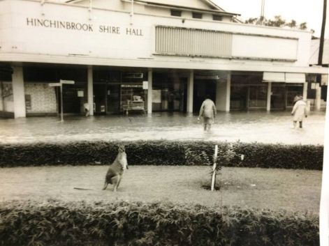
Drowned Cane and Soured Land: Floods in the Lower Herbert Valley
Sourced from the Upper Herbert catchment at Herberton and channelled swiftly down the basalt ranges into the Lower Herbert Valley, monsoonal floodwaters have flowed through time‑worn rivers, streams and tributaries, spreading across lagoons and crevices of the delta over millennia.

Floods in the Lower Herbert Valley have long played a role in the natural cycle of growth, cleansing and renewal across the land, shoreline and surrounding seascapes.
Aboriginal people traditionally moved seasonally across the floodplain in response to the landscape, while later settlers established permanent homes, planting cane and raising livestock year‑round.
This left communities vulnerable during the wet season from December to April, when flooding occurred regularly.
Stories of both heroism and tragedy remain.
In 1894, Mr and Mrs Buchanan and their five young children lost their lives in rising floodwaters despite rescue attempts from nearby residents.
At its peak, the flood level rose 900 mm higher than the 1890 inundation.
Flooding affected more than crops. Livestock losses were significant, and many risked their lives trying to save animals.
In 1904, Reginald Boyd of Ripple Creek attempted to move 18 draught horses across the flooded Seymour River.
Five were lost along the way, and the following day he discovered further losses, including a prized stallion and eight mares.

In 1927, the region experienced its largest recorded flood, associated with a cyclone. Known as “Black Thursday,” the event claimed 53 lives and resulted in widespread loss of livestock and property.
Waters rose approximately 900 mm above the 1894 level, reaching the upper floor of the Hinchinbrook Hotel.
Low-lying areas were inundated, homes were swept from their stumps, and entire families were displaced.
In one tragic event, only four out of fourteen people survived when a house broke free and was carried towards the coast.
Since 1927, the Lower Herbert Valley has experienced numerous major floods, shaping both the landscape and the resilience of the community. Rain in the hinterland continues to bring both preparation and reflection for those who live here.
Are you ready for the next big flood?
Images provided by the Ingham Family History Photographic Collection.